

Why Beijing's Oceanographic Research Irks Philippines: Seen as Precursors to Military Expansion in Contested Waters of South China Sea
The Xiang Yang Hong 33 incident exemplifies a broader challenge in the South China Sea. For China, the mission is characterized as routine environmental research conducted in the waters. The Philippines does not view Chinese marine scientific surveys as isolated environmental initiatives
 Jul 15, 2026
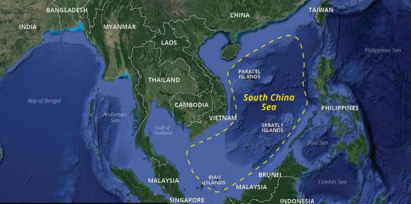
In May 2026, the Chinese oceanographic research vessel Xiang Yang Hong 33 became the latest source of tension between China and the Philippines. Manila accused the Chinese vessel of conducting unauthorized marine scientific research inside the Philippine Exclusive Economic Zone (EEZ). Philippine Coast Guard (PCG) patrols tracked the ship near several disputed features, including Iroquois Reef, Sabina Shoal, and areas surrounding Pag-asa Island. While observing the deployment of service boats and the presence of accompanying Chinese Coast Guard and maritime militia vessels. Manila argued that these activities violated the United Nations Convention on the Law of the Sea (UNCLOS), which requires the consent of the coastal state for marine scientific research within its EEZ.
Philippine Coast Guard spokesperson for the West Philippine Sea, Rear Admiral Jay Tarriela, said the ship's track during the following weeks took it past Sabina Shoal, Second Thomas Shoal, Mischief Reef, and Jackson Atoll, among other features inside the Kalayaan Island Group. On 6 May, a PCG surveillance aircraft tracked the vessel roughly 7.34 nautical miles west of Rozul Reef (Iroquois Reef), at the southern end of Reed Bank, and observed it deploying a service boat toward the reef, which the Coast Guard described as confirmation of ongoing unauthorized research operations; a Chinese coast guard vessel and thirteen maritime militia ships were also observed anchored nearby.
The episode intensified further over the weekend of 16–17 May, when the PCG detected the Xiang Yang Hong 33 and two China Coast Guard vessels, CCG 5101 and CCG 5309, operating inside the 12-nautical-mile territorial sea of Pag-asa (Thitu) Island, the largest Philippine-occupied feature in the Spratlys. Chinese personnel were ferried by rigid-hulled inflatable boats to two sandbars, Cay-2 and Cay-3, within Pag-asa's territorial waters. The Philippine Coast Guard concluded that the vessel had been systematically conducting illegal marine scientific research throughout Philippine waters since entering the EEZ nearly a month earlier. Beijing rejected the allegations and argued that Xiang Yang Hong 33, was conducting a legitimate marine ecological survey in waters under Chinese jurisdiction. China Coast Guard spokesperson Jiang Lue accused Philippine aircraft of harassing the research mission. Also described Manila's action as a distortion of facts. According to Beijing, scientific surveys are normal activities intended to support environmental research and maritime management.
Why Manila Distrusts Chinese Scientific Activities
For the Philippines, Xiang Yang Hong's 33 activities extend beyond the actions of a single research vessel. Philippine concerns are informed by a broader historical pattern in which activities initially presented by China as civilian, humanitarian, or scientific have subsequently evolved into permanent strategic footholds. Previous incidents in the South China Sea have demonstrated that civilian and scientific activities can facilitate tactical consolidation and military expansion.
From Scientific Stations to Permanent Presence 1988–1995
During the early stages of China's presence at several reefs and shoals, Chinese authorities frequently described their activities as civilian, humanitarian, or scientific. The process began in 1988, when China established its first permanent presence on Fiery Cross Reef (Yongshu Reef). Throughout the 1990s and 2000s, the reef contained only modest facilities, including a platform, communications equipment, and accommodation for personnel. During the same year, China also seized Johnson South Reef following a naval clash with Vietnam and gradually built small military structures there. Although these outposts were limited in scale, they served as a springboard for future expansion.
The next major development occurred in 1995, when China erected wooden structures on Mischief Reef, which lies within the Philippines' Exclusive Economic Zone. Beijing explained that the structures were temporary shelters and were intended to protect Chinese fishermen from storms. However, over the following years, these huts were replaced by larger concrete buildings equipped with communications systems and military personnel. The transformation of what had initially been described as fishing shelters into a permanent outpost became one of the principal reasons behind Philippine distrust of subsequent Chinese activities in the South China Sea.
The Island-Building Campaign, 2013–2015
The situation remained relatively stable for two decades. However, beginning in 2013, China initiated an unprecedented island-building operation across the Spratly Islands. The first stage entailed extensive land reclamation using giant dredgers to convert reefs and low-tide elevations into artificial islands. In 2014, large-scale dredging operations commenced at Fiery Cross Reef, eventually expanding it to approximately 2.7 square kilometers. During the same period of time, reclamation also began at Subi Reef, Mischief Reef, Cuarteron Reef, Hughes Reef, Gaven Reef, and Johnson South Reef. Beijing justified these activities as necessary to improve living conditions, provide maritime search-and-rescue services, and support scientific and environmental work.
By 2015, the scale of construction had become apparent through satellite imagery. At Fiery Cross Reef, China completed massive land reclamation and began constructing a 3,125-meter runway, deep-water harbor facilities, fuel storage sites, radar installations, and large administrative buildings. Similar developments were underway at Subi Reef, where reclamation transformed a previously submerged feature into a 3.95-square-kilometer artificial island. Construction included a 3,000-meter airstrip, harbor facilities, power plants, housing complexes, and communications infrastructure. Meanwhile, Mischief Reef underwent the most extensive reclamation project, creating approximately 5.6 square kilometers of new land and initiating the construction of another 3,000-meter runway and a large naval harbor. At Cuarteron Reef, China built a harbor, multi-story structures, and a helipad, while Hughes Reef, Gaven Reef, and Johnson South Reef received expanded buildings and support facilities.
The Dual-Use Debate 2016–2018
These installations entered a new phase in 2016 and revealed China's true intent in the South China Sea. China completed runways at Fiery Cross Reef, Subi Reef, and Mischief Reef, conducted civilian test flights, and presented the facilities as contributions to regional transportation and humanitarian services. Beijing inaugurated a 55-meter lighthouse at Subi Reef and emphasized the role of these islands in navigation safety, weather forecasting, and disaster relief. But satellite imagery revealed that these facilities possessed obvious dual-use capabilities. The same year, the Permanent Court of Arbitration in The Hague ruled that features such as Mischief Reef and Subi Reef were low-tide elevations and that China's expansive claims lacked legal basis, a ruling Beijing rejected.
Between 2016 and 2017, the three major outposts evolved in the South China Sea into sophisticated military bases. At Fiery Cross Reef, China constructed twelve hardened aircraft shelters, radar systems, anti-aircraft weapons, and infrastructure capable of hosting fighter aircraft and H-6 bombers. Subi Reef acquired aircraft hangars, electronic warfare facilities, radar arrays, and missile shelters. Mischief Reef developed extensive barracks, communications facilities, and logistical infrastructure. Simultaneously, Cuarteron Reef became an important surveillance node with advanced radar systems, while Hughes Reef, Gaven Reef, and Johnson South Reef received additional defensive installations and communications equipment.
Satellite imagery of 2018 confirmed the deployment of surface-to-air missile systems, anti-ship cruise missiles, electronic intelligence equipment, and underground storage facilities on several of these islands. Activities that began as scientific stations and fishing shelters have developed into an integrated network of military bases capable of projecting Chinese air and naval power throughout the South China Sea.
As per this progression, done by China, from the establishment of an oceanographic station at Fiery Cross Reef in 1988, to fishing shelters at Mischief Reef in 1995, and ultimately to extensive land reclamation and militarization between 2013 and 2018, constitutes the historical context for current Philippine concerns regarding Chinese activities, including the 2026 surveys by the Xiang Yang Hong 33. For the Philippines, the central issue is not solely the stated purpose of a single research vessel, but whether contemporary scientific missions may signal the beginning of another extended process of strategic consolidation.
The Xiang Yang Hong 33 incident exemplifies a broader challenge in the South China Sea. For China, the mission is characterized as routine environmental research conducted in the waters. While the Philippines adopts a more suspicious interpretation due to previous incidents in the South China Sea. Manila does not view Chinese marine scientific surveys as isolated environmental initiatives, but rather as potential precursors to the gradual expansion of China's physical and operational presence.
In this context, scientific research has become inseparable from geopolitical considerations. Each survey mission is increasingly viewed not only as a pursuit of knowledge but also as a potential initial step in a broader campaign to consolidate influence over contested waters.
(The author is a geopolitical and strategic affairs researcher who is a postgraduate in political science and international relations, University of Hyderabad, India. The views expressed are personal. He can be contacted at amitkr8953@gmail.com )







Post a Comment